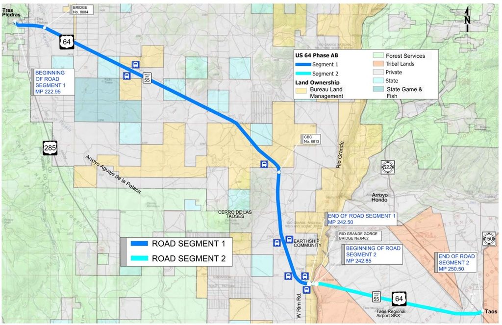
NMDOT is planning to re-design US 64 from Tres Piedras to the intersection with NM150 (KTAO / “Old Blinking Light”). This is a generational opportunity to get safe bicycle and pedestrian infrastructure included in the design plan!
This segments are Tier 1 and 2 priorities in NM Statewide Prioritized Bicycle Plan and are a key link in several long-distance biking and hiking routes through Northern New Mexico. They should be designed to accommodate the current and anticipate future alternative transportation uses.
On the plus side, NMDOT is considering a 10-foot path on Segment 2 as one possible alternative, but they are only considering 6-foot wide shoulders on Segment 1, which is not wide enough to ensure bicycle and pedestrian safety.
Let NMDOT know you want to see:
• 8 to 10-foot shoulders for the entirety of Segment 1 (Neither Current Alternative) •
• 8-foot shoulders and a separated 10-foot bike path for the entirety of Segment 2 (Alternative 2-4) •
Project Page: NMDOT Tres Piedras to Taos Project Page
Public Meeting Details: NMDOT Public Meeting Event Page
Submit Written Comments by October 20th!
Online: use the comment form available here: https://www.dot.nm.gov/event/tres-piedras-to-taos/
By email: yomara.laurenzana@nv5.com
By USPS Mail:
Attn: US 64 Alignment Study
NV5, Inc.
6501 Americas Parkway, Suite 400
Albuquerque, NM 87110
By Phone:
575-973-2300
Project Details
The project is divided into two sections running West to East: Segment 1 from Tres Piedras to the Rio Grande Gorge Bridge (high bridge) and Segment 2: running from the Rio Grande Gorge Bridge to the intersection with NM150 at KTAO a.k.a. the “Old Blinking Light”
Below are detailed descriptions of what we would like to see to advocate for increased pedestrian, bicycle, and driver safety along these two segments and why.
Segment 1: Tres Piedras to Rio Grande Gorge Bridge
Proposed Action
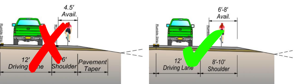
NMDOT is proposing Alternative 1-2 or Alternative 1-3 which BOTH only have 6-foot shoulders, which would mean only 4.5 feet of available space for bicycles and pedestrians after you add rumble strips.
The Ask
Please add 8–10-foot shoulders providing at least 6 feet of usable space for biking and walking.
Why It Matters
This is a long-term safety investment. We should build for future traffic and recreation over the next 50 years, not just current volumes. Wide shoulders buffer cyclists and pedestrians from vehicle traffic and serve growing access to regional trails and public lands. Once reconstructed, this roadway won’t be updated again for decades.
NMDOT’s justification that traffic volume and speeds don’t warrant wider shoulders does not consider the high vehicle speeds (well beyond posted limits) typically seen on this road, nor does it consider the increasing volume of bicycle and pedestrian traffic as we expand regional outdoor recreation networks.
Talking Points
- The community wants 8–10-foot shoulders, with at least 6 feet of usable space, throughout the segment.
- A shoulder that provides only 4.5 feet of usable space is not enough on a high-speed highway that is the primary link.
- Build for future traffic and recreation, not just current conditions.
- Shoulders deteriorate over time; starting wider ensures long-term usable safety margins.
- This corridor connects Taos to regional trails, public lands, and bicycle tourism destinations, as well as current and potential popular gravel routes on the Rio Grande del Norte National Monument. Specific routes include:
- Rio Grande Trail (planned)
- Tour Divide Route
- Carson Continental Divide Epic
- Chama Charmer Bikepacking Route
- Multiple loops on the Rio Grande del Norte National Monument and connecting up to Colorado
- Investing in safe, wide shoulders boosts local economic development by supporting bicycle tourism and recreational spending.
Pedestrian and bicyclist safety is not a “nice to have” afterthought “if there is enough money”, but should be considered as fundamental to a highway budget as the asphalt, guardrails, and paint for striping.
Segment 2: High Bridge to NM 150 (KTAO / OBL)
Proposed Action
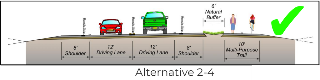
NM-DOT is considering Alternatives 2-2/2-3 which both include 8-10 foot shoulders only or Alternative 2-4 which includes 8-foot shoulders AND a separated 10-foot wide multi-use path.
The Ask
Please select Alternative 2.4: 8-foot shoulders and a separated 10-foot multi-use path.
Why It Matters
A separated path is significantly safer and more comfortable than riding alongside highway traffic, benefiting both residents and visitors while expanding the regional trail network. The Rio Grande Trail (which will cross at the bridge), new housing developments, and other regional recreation routes will increase bicycle, pedestrian, and vehicle traffic between Taos and the High Bridge. This path will also be a continuation of the multi-use path from Arroyo Seco to KTAO (currently in planning).
Talking Points
- The community wants Alternative 2.4: 8-foot shoulders a separated 10-foot multi-use path,
- Have the path as far away from the road as possible. Six feet should be the minimum, with more separation wherever feasible.
- Create curves as possible to make the path an enjoyable part of the regional trail system, not just a narrow strip alongside the highway.
- The High Bridge is a popular destination on the Rio Grande del Norte National Monument. A pathway can reduce vehicle traffic.
- Existing and planned trails will bring more people between Taos and the High Bridge, including:
- Rio Grande Trail (planned)
- West Rim Trail
- Tour Divide Route
- Carson Continental Divide Epic
- Chama Charmer Bikepacking Route
- Multiple loops on the Rio Grande del Norte National Monument and connecting to Colorado
- Planned housing development will increase traffic, so the design needs to anticipate future demand.
- Connect this project to the multi-use path from Arroyo Seco to KTAO (in planning).
- Support local businesses and economic development by capturing bicycle tourism and daily visitor spending through dedicated multi-use infrastructure.
Did you know: The State of Utah recently committed $45 MILLION per year to build out a 3,100-mile network of separated pathways connecting the entire state? Seems like we should be able to get a 7-mile path in Northern New Mexico…
Detailed Information and Statistics
Use these key statistics and references to support your public comments and letters.
A. What Alternatives NMDOT is Considering
https://www.dot.nm.gov/wp-content/uploads/2026/05/CN-5101660-Public-Meeting.pdf
https://www.dot.nm.gov/wp-content/uploads/2026/05/CN-5101660-Public-Meeting-Boards.pdf
Segment 1: Tres Piedras to Rio Grande Gorge Bridge
- 6-foot shoulders, with approximately 4.5 feet of usable bicycle and pedestrian space.
- Guardrails positioned to maintain consistent usable shoulder space.
- Note: NMDOT claims current traffic volumes do not justify wider shoulders.
Segment 2: High Bridge to NM 150
- Alternative 2.2: 8-foot shoulders.
- Alternative 2.3: 8-foot shoulders.
- Alternative 2.4: 8-foot shoulders and a separated 10-foot multi-use path (Preferred Advocacy Option).
B. New Mexico Statewide Bicycle Plan
Source: NM Statewide Bicycle Plan Document
Bicyclist Comfort & Safety Guidelines
- “Of all factors, the presence of shoulders had the most consistent impact on bicyclist comfort. Based on the images of roadways used in the survey, context, traffic volume, and speed have a less conclusive impact on bicyclist comfort than the presence of shoulders or bike lanes among respondents.” (NM Statewide Bike Plan, p. 27)
- “For rural highways a Tier 1 designation also indicates that a more robust level of infrastructure is desired than a Tier 2 route….As a best practice, dedicated bikeway facilities should be provided to the greatest extent possible on Tier 1 and 2 routes during rehabilitation or reconstruction projects.” (NM Statewide Bike Plan, p. 66)
- “Per the AASHTO Guide for the Development of Bikeway Facilities, 4th Ed., the minimum operational shoulder width, or effective width, shall be at least four feet of clear space. Paved shoulder widths greater than five feet are desirable on higher-speed/higher volume roadways.” (NM Statewide Bike Plan, p. 90)
Economic Impact & Tourism Stats
Investing in safe bicycling infrastructure directly boosts the local economy by encouraging outdoor recreation and bike tourism. Key findings from the NM Statewide Bike Plan survey:
- 91% of respondents bike for exercise or recreation.
- 80% take all-day or multi-day recreational rides.
- 85% of multi-day riders spend an average of $59 per person per day during their ride. (p. 25)
- 4.2% of overnight visitors report bicycling while visiting New Mexico, compared to the US national average of 3.5%. (p. 39)
C. NMDOT Vulnerable Road User Safety Assessment
Source: 2023 NMDOT Vulnerable Road User Safety Assessment and Appendices
Speed & Crash Severity Factors
- “Also, roads with a speed limit of 50 miles per hour (mph) or higher contained the highest proportion of KA crashes along the roadway, at 30%.” (Section 2.3.2)
- “Roads with speed limits above 40 MPH represent a disproportionately high percentage of bicyclist-involved KA crashes compared to the share of the state’s roadways that have these speed limits… in 95% of bicyclist-involved crashes, the bicyclist was riding on a roadway without a bicycle facility present.” (Section 2.4.2) (KA = Killed or Incapacitated)
High Injury Network (HIN)
- “Of the vulnerable road user crashes on all public roadways in New Mexico, 84% of all injury-causing VRU-involved crashes and 91% of fatal vulnerable road user crashes occurred on roads classified as major collectors or higher, or at intersections with these roads, despite accounting for only 20% of centerline miles in the state.” (Section 3.1)
Potential Crash Reductions
- Upgrading narrow, unpaved shoulders (<5 ft) to wide, paved shoulders (>5 ft): 42% potential crash reduction
- Installing separated bicycle facilities: 54% potential crash reduction (Alternatives Safety Assessment)
D. Regional Recreation and Trail Connections
- Continental Divide Trail (west of Tres Piedras): Popular long-distance biking route considered under the BOLT Act.
- Chama Charmer: Chama Charmer Bikepacking Route
- La Paliza Grande: La Paliza Grande Route Info
- John Dunn Bridge Road: Connects to gravel-riding and trail-running around Cerro de la Olla, volcanic cones, Miner’s Trail, and Colorado.
- Rio Grande Trail: Planned state-wide through-route connecting Taos to the High Bridge.
Public Comment Examples
The deadline for written comments is November 8th and can be submitted here.
At a loss for words?
Below you’ll find some examples of public comments, feel free to copy and paste any of our examples or modify them to make them your own.
- Adding a multi-use path from Highway 150 to the High Bridge and providing eight-foot shoulders along the length of the project with six feet of usable space for pedestrians and cyclists would be a huge benefit to our community and would provide critical safety infrastructure that would allow members of our community to safely exercise and commute.
- Implementing a multi-use path from Highway 150 to the High Bridge and providing eight-foot shoulders along the length of the project with six feet of usable space for pedestrians and cyclists would support Taos’ economy as a main hub of outdoor access in New Mexico. As a small business owner, I appreciate the value these improvements will bring to our community by providing more reasons for folks to stay and shop in our community.
- The high rate of pedestrian and cyclist fatalities in New Mexico is unacceptable and needs to be addressed. The NMDOT has an opportunity with the US 64 Alignment Improvement Study to set an example for the rest of the state on what safe streets could look like and to show that they care about the safety of our communities.To address pedestrian and cyclist fatalities and non-fatal collisions, the NMDOT needs to add a multi-use path from Highway 150 to the High Bridge and provide eight-foot shoulders along the length of the project with six feet of usable space for pedestrians and cyclists.
- The US 64 Alignment Improvement Study is a perfect opportunity for the NMDOT to implement the needed improvements that were identified in the 2018 NMDOT New Mexico Prioritized Statewide Bicycle Network Plan. The plan explicitly states that “dedicated bikeway infrastructure should be incorporated along all Tier 1 and Tier 2 facilities where right-of-way exists, even when portions of a corridor are constrained.” The infrastructure improvements we would like to see implemented are:A separated multi-use path for cyclists and pedestrians on Road Segment 2 from NM 150 to the High Bridge, which is identified as a Tier 1 priority. An eight-foot shoulder with six feet of usable space for pedestrians and cyclists along the length of Road Segment 1 from the High Bridge to Tres Piedras, which is identified as a Tier 2 priority.